About
The Ontario government generates and maintains thousands of datasets. Since 2012, we have shared data with Ontarians via a data catalogue.
Open Data
Open data is data that is shared with the public. Click here to learn more about open data and why Ontario releases it.
Ontario’s Digital and Data Directive states that all data must be open, unless there is good reason for it to remain confidential.
Ontario’s Chief Digital and Data Officer also has the authority to make certain datasets available publicly.
Other data
Datasets listed in the catalogue that are not open will have one of the following labels:
- Under review – The dataset is still being screened. It may become open or it may be restricted and not released.
- Restricted – The dataset has been screened and will not be released to the public. The record will be listed in the catalogue, but the data will not be shared.
Data licences and use
If you want to use data you find in the catalogue, that data must have a licence – a set of rules that describes how you can use it. A licence:
- grants you rights to download and use the data
- outlines your rights
- tells you what terms and conditions apply
Most of the data available in the catalogue is released under Ontario’s Open Government Licence. However, each dataset may be shared with the public under other kinds of licences or no licence at all.
If a dataset doesn’t have a licence, you don’t have the right to use the data.
If you have questions about how you can use a specific dataset, please contact us.
Developers resources
Data
The Ontario Data Catalogue endeavors to publish open data in a machine readable format. For machine readable datasets, you can simply retrieve the file you need using the file URL.
The Ontario Data Catalogue is built on CKAN, which means the catalogue has the following features you can use when building applications.
APIs (Application programming interfaces) let software applications communicate directly with each other. If you are using the catalogue in a software application, you might want to extract data from the catalogue through the catalogue API.
Note: All Datastore API requests to the Ontario Data Catalogue must be made server-side.
Catalogue API
The catalogue's collection of dataset metadata (and dataset files) is searchable through the CKAN API. The Ontario Data Catalogue has more than just CKAN's documented search fields. You can also search these custom fields. You can also use the CKAN API to retrieve metadata about a particular dataset and check for updated files.
Read the complete documentation for CKAN's API.
Datastore API
Some of the open data in the Ontario Data Catalogue is available through the Datastore API. You can also search and access the machine-readable open data that is available in the catalogue.
How to use the API feature:
- Find your dataset.
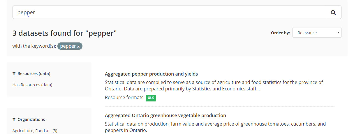
Figure 3 – Dataset search results for “pepper”. - Click Preview to go to the file you want to access through the API.
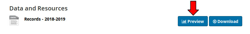
Figure 4 – Click the Preview button. - Click the Data API button.
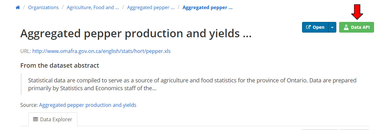
Figure 5 – Click the Data API button and follow the instructions.
Read the complete documentation for CKAN's Datastore API.
Training materials
How to use the catalogue
The Ontario Data Catalogue contains a record for each dataset that the Government of Ontario possesses. Some of these datasets will be available to you as open data. Others will not be available to you. This is because the Government of Ontario is unable to share data that would break the law or put someone's safety at risk.
Search
You can search for a dataset with a word that might describe a dataset or topic. Use words like “taxes” or “hospital locations” to discover what datasets the catalogue contains.
You can search for a dataset from 3 spots on the catalogue:
- the homepage,
- the dataset search page, or
- the menu bar available across the catalogue.
On the dataset search page, you can also filter your search results. You can select filters on the left hand side of the page to limit your search for datasets with your favourite file format, datasets that are updated weekly, datasets released by a particular ministry, or datasets that are released under a specific licence. Go to the dataset search page to see the filters that are available to make your search easier.
You can also do a quick search by selecting one of the catalogue’s categories on the homepage. These categories can help you see the types of data we have on key topic areas.
When you find the dataset you are looking for, click on it to go to the dataset record.
Dataset record
Each dataset record will tell you whether the data is available, and, if so, tell you about the data available.
Open Data
An open dataset might contain several data files. These files might represent different periods of time, different sub-sets of the dataset, different regions, language translations, or other breakdowns. You can select a file and either download it or preview it. Make sure to read the licence agreement to make sure you have permission to use it the way you want.
Non-open data
A non-open dataset may be not available for many reasons.
Read more about non-open data.
Read more about restricted data.
Data that is non-open may still be subject to freedom of information requests.
Visualizing data
The catalogue has tools that enable all users to visualize the data in the catalogue without leaving the catalogue – no additional software needed.
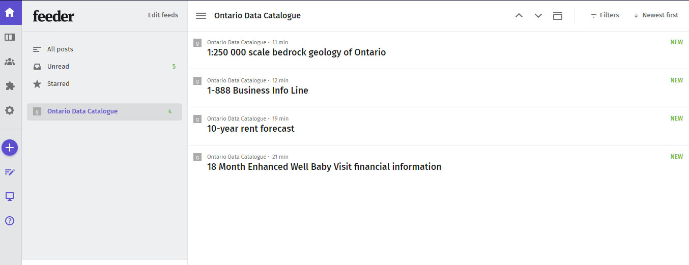
Keeping updated
Get automatic notifications when datasets are updated. You can choose to get notifications for individual datasets, an organization’s datasets or the full catalogue.
You don’t have to provide and personal information – just subscribe to our feeds using any feed reader you like using the corresponding notification web addresses. Copy those addresses and paste them into your reader.
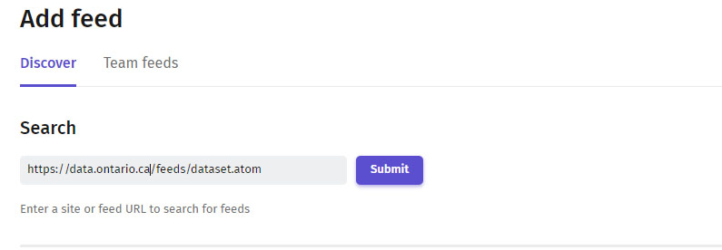
Your feed reader will let you know when the catalogue has been updated.
File Types
The catalogue provides open data in several file formats (e.g., spreadsheets, geospatial data, etc). Learn about each format and how you can access and use the data each file contains.
- CSV - Comma Separated Values
-
A file that has a list of items and values separated by commas without formatting (e.g. colours, italics, etc.) or extra visual features. This format provides just the data that you would display in a table. XLSX (Excel) files may be converted to CSV so they can be opened in a text editor.
How to access the data: Open with any spreadsheet software application (e.g., Open Office Calc, Microsoft Excel) or text editor.
Note: This format is considered machine-readable, it can be easily processed and used by a computer. Files that have visual formatting (e.g. bolded headers and colour-coded rows) can be hard for machines to understand, these elements make a file more human-readable and less machine-readable.
- Txt – Text file
-
A file that provides information without formatted text or extra visual features that may not follow a pattern of separated values like a CSV.
How to access the data: Open with any word processor or text editor available on your device (e.g., Microsoft Word, Notepad).
- XLS/XLSX – Excel Spreadsheet
-
A spreadsheet file that may also include charts, graphs, and formatting.
How to access the data: Open with a spreadsheet software application that supports this format (e.g., Open Office Calc, Microsoft Excel). Data can be converted to a CSV for a non-proprietary format of the same data without formatted text or extra visual features.
- SHP – Shapefile
-
A shapefile provides geographic information that can be used to create a map or perform geospatial analysis based on location, points/lines and other data about the shape and features of the area. It includes required files (.shp, .shx, .dbt) and might include corresponding files (e.g., .prj).
How to access the data: Open with a geographic information system (GIS) software program (e.g., QGIS).
- Zip – Compressed file
-
A package of files and folders. The package can contain any number of different file types.
How to access the data: Open with an unzipping software application (e.g., WinZIP, 7Zip).
Note: If a ZIP file contains .shp, .shx, and .dbt file types, it is an ArcGIS ZIP: a package of shapefiles which provide information to create maps or perform geospatial analysis that can be opened with ArcGIS (a geographic information system software program).
- GeoJSON – Geographic JavaScript Object Notation
-
A file that provides information related to a geographic area (e.g., phone number, address, average rainfall, number of owl sightings in 2011 etc.) and its geospatial location (i.e., points/lines).
How to access the data: Open using a GIS software application to create a map or do geospatial analysis. It can also be opened with a text editor to view raw information.
Note: This format is machine-readable, and it can be easily processed and used by a computer. Human-readable data (including visual formatting) is easy for users to read and understand.
- JSON - JavaScript Object Notation
-
A text-based format for sharing data in a machine-readable way that can store data with more unconventional structures such as complex lists.
How to access the data: Open with any text editor (e.g., Notepad) or access through a browser.
Note: This format is machine-readable, and it can be easily processed and used by a computer. Human-readable data (including visual formatting) is easy for users to read and understand.
- XML - Extensible Markup Language
-
A text-based format to store and organize data in a machine-readable way that can store data with more unconventional structures (not just data organized in tables).
How to access the data: Open with any text editor (e.g., Notepad).
Note: This format is machine-readable, and it can be easily processed and used by a computer. Human-readable data (including visual formatting) is easy for users to read and understand.
- KML- Keyhole Markup Language
-
A file that provides information related to an area (e.g., phone number, address, average rainfall, number of owl sightings in 2011 etc.) and its geospatial location (i.e., points/lines).
How to access the data: Open with a geospatial software application that supports the KML format (e.g., Google Earth).
Note: This format is machine-readable, and it can be easily processed and used by a computer. Human-readable data (including visual formatting) is easy for users to read and understand.
- IVT – Table files
-
This format contains files with data from tables used for statistical analysis and data visualization of Statistics Canada census data.
How to access the data: Open with the Beyond 20/20 application.
- Application/ msaccess – MS Access Database
-
A database which links and combines data from different files or applications (including HTML, XML, Excel, etc.).
The database file can be converted to a CSV/TXT to make the data machine-readable, but human-readable formatting will be lost.
How to access the data: Open with Microsoft Office Access (a database management system used to develop application software).
- PDF - Portable Document Format
-
A file that keeps the original layout and formatting of a page. The contents of a PDF cannot be edited directly.
How to access the data: Open with web browsers, PDF readers, and word processors.
- DOC/DOCX – Word Document
-
A text file which can include images, tables and many other formatting options.
How to access the data: Open with doc/docx compatible word processors.
- RTF – Rich Text Format
-
A text file which can include basic text formatting and images.
How to access the data: Opens with most word processors (e.g., OpenOffice).
Interpreting data
Open data on the Ontario Data Catalogue will vary in how it is organized and formatted. Depending on the licence agreement for a dataset, you can choose to organize and format the file to suit your intended use.
Some of the open data on the Ontario Data Catalogue will have a data dictionary. A data dictionary can help you understand what the dataset means.
If you need further understanding the data, reach out to the dataset point of contact.
What do we tell you about data (metadata)?
Each dataset listed in the catalogue might have the following details as part of its description:
Files
Each dataset listed in the catalogue might include multiple related files. Each file might have the following details in its description:
Engagement
We built Ontario’s data catalogue to give you better access to government data.
Here is how you can give us feedback:
- Contact us.
As we improve the catalogue, we want you to tell us what you think of it. This catalogue is for you, so the more feedback we get, the better our final product.
- Participate in user testing.
Work with us directly by testing the catalogue in our offices. If you are interested in doing this, contact us.
- Complete a survey.
You may come across a survey while using the catalogue. Please complete the survey and tell us how we’re doing.